Live updates: The latest on Triangle road conditions, RDU flight status, power outages
By Korie Dean and
Chantal Allam
READ MORE
Winter storm in the Triangle
From the forecast and power outages to closings, road conditions and sporting events, here’s everything you need to know about the winter storm in the Triangle.
Expand All
RALEIGH
Updated 8:10 a.m.: With the winter storm having passed, a sigh of relief might be in order Saturday morning. There are power outages and dangerous roads and canceled or delayed flights, but not at the levels forecasts suggested were possible.
Roads in the Triangle have improved since Friday night. Wake and Durham counties report that their roads are partially covered with snow and ice, an improvement from completely covered Friday night. Orange and Johnston counties report clear roads with patches of snow or ice.
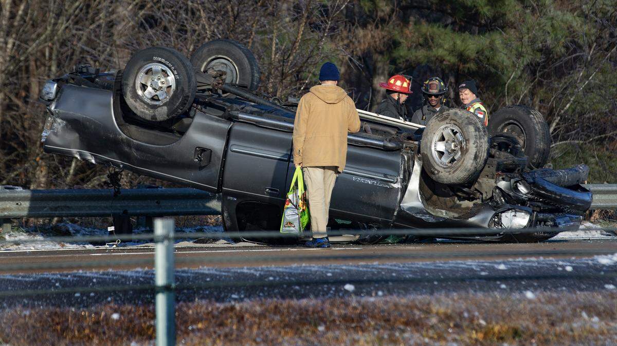
Firefighters and the driver survey the remains of an overturned car in the westbound lanes of US 64 in Wendell Saturday morning as many slick spots remain, even on main roads and bridges. Scott Sharpe ssharpe@newsobserver.com
About 6,900 customers are without power in North Carolina, less than 1,000 of them in the Triangle.
Raleigh-Durham International Airport is still recovering from the storm with many flights canceled or delayed Saturday morning. Check with your airline if you are planning to fly or pick people up at the airport today.
A NC Dept. of Transportation crew prepares to clear a tree drooping from the weight of ice that blocks Yates Mill Pond Road near the intersection with Penny Road south of Downtown Raleigh Saturday morning. Scott Sharpe ssharpe@newsobserver.com
Previously:
Updated 11:30 p.m.: The Triangle saw snow for the first time after a years-long drought Friday and conditions have worsened as the night progresses, with the snow giving way to sleet and freezing rain.
Counties that reported clear roads earlier are now reporting roads partially covered with snow and ice. Power outages are creeping up across the state. And traffic accidents are causing additional problems.
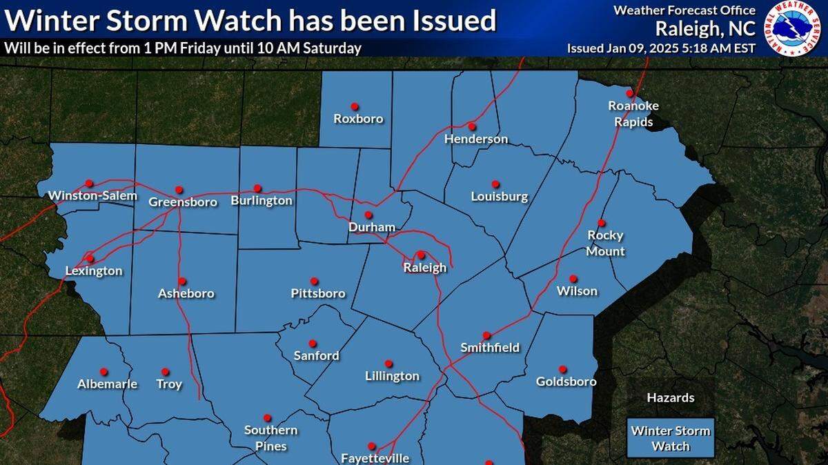
A winter storm warning, issued by the National Weather Service in Raleigh, is in effect until 10 a.m. Saturday.
At 10 p.m. Friday, the NWS reported that most of the precipitation affecting the Triangle had transitioned from snow to sleet and freezing rain. It warned that the freezing rain is expected to continue through the night, so we can “expect glazing and the accretion of ice on power lines to increase.”
In addition to extremely treacherous roads, that all but certainly means more widespread power outages through Saturday morning.
William Dowling, 11, of Raleigh, watches the snow come down outside Reynolds Coliseum in Raleigh, N.C., Friday, Jan. 10, 2025. Ethan Hyman ehyman@newsobserver.com
Handful of crashes close roads in Wake County
Updated 8:49 p.m.: Several car crashes in icy conditions have closed portions of I-440 and I-87 in Wake County, according DriveNC.com, the online platform tracking real-time traffic.
Southbound I-87 is closed past Exit 13 (US 64 BUS) near Knightdale/Mile Marker 12. WRAL reported that multiple vehicles were involved in the crash, but that it produced only minor injuries.
The storm has also disrupted air travel. Roughly 55 flights have been canceled at Raleigh-Durham International (RDU) Airport in the last 24 hours, according to Flightaware, an aviation blog featuring real-time statistics and flight tracker links.
Most cancellations are earmarked for later tonight and early Saturday, according to RDU’s website. Check with your airline if you’re expecting to fly out of RDU tonight or Saturday morning.
Previously:
Roads still mostly clear across the Triangle
Updated 8 pm.: Triangle counties are reporting mostly clear roads at 8 p.m. Friday, despite a couple of hours of flurries and mixed precipitation.
There are icy spots, especially on area bridges. No major accidents have been reported, but roads are likely to become “slick and hazardous” as the evening progresses.
Flurries and some accumulation have been spotted in Raleigh, Apex and Cary.
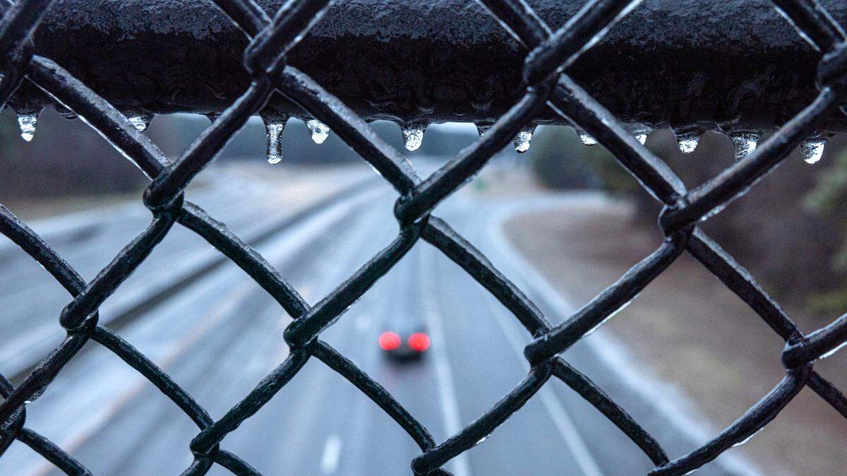
U.S. 540 crossing over U.S. 1 in Wake County Friday evening shows that bridges, do indeed, freeze first. DriveNC.gov
Wintry precipitation moves into Triangle
Updated 4:38 p.m.: A mix of wintry precipitation made its way to the Triangle as the evening commute began.
Light snow flurries were seen in Chapel Hill and Cary, among other areas. Parts of Raleigh and Apex were experiencing flurries and sleet.
Sandhya Purohit, a N.C. State senior and Ashley Garcia, a N.C. State junior, enjoy the falling snow while on campus in Raleigh, N.C., Friday evening, Jan. 10, 2025. Ethan Hyman ehyman@newsobserver.com
Snow falling in the Sandhills; Triangle up next
Updated 3:45 p.m.: Snow started falling in central North Carolina earlier in the afternoon, including the western Piedmont and Sandhills, according to the National Weather Service. The weather service predicted earlier in the afternoon that light snow could arrive to the Triangle beginning around 3:30.
1:38 PM update: We are getting reports that a band of light snow is reaching the ground over the western Piedmont & Sandhills. Snow should accumulate fairly quickly with the cold ground, so drivers should exercise caution. This will reach the Triangle in the next 2-3 hours. #ncwxpic.twitter.com/gNHCU7q2Qj
Johnny Howard places plastic sleds and snow discs around his pickup truck as snow begins to fall in Pittsboro, Friday afternoon, Jan. 10, 2025. Howard was selling the sleds to customers hoping for sledding weather. Scott Sharpe ssharpe@newsobserver.com
Stein gives update on storm preparations
Updated 1:18 p.m. Gov. Josh Stein and state officials asked North Carolinians to continue monitoring their local weather forecasts to stay up-to-date on the conditions near them, and recommended people stay home and keep off roads that could see a mix of snow, sleet and freezing rain.
Stein declared a statewide state of emergency Thursday, activating resources to help with the storm response.
During a news conference Friday, Stein said officials expect the winter storm to hit much of the state, and said the greatest concern right now is road safety.
“Precipitation and freezing temperatures tomorrow afternoon and tonight will make a mess of the roads on Saturday morning,” Stein said. “The thawing and re-freezing of precipitation leads to ice, so that everyone needs to be careful on our roads.”
Shelita Richmond throws a snowball at her fiance Brandon Palmer outside Reynolds Coliseum on the campus of N.C. State in Raleigh, N.C., Friday, Jan. 10, 2025. Ethan Hyman ehyman@newsobserver.com
Stein said emergency management officials recommend people pay attention to their local forecasts and be prepared for what’s expected in their area, keep cellphones and spare batteries charged in case of power outages, avoid the roads unless necessary, and store an emergency kit in their vehicles with food, an ice scraper, jumper cables, a flashlight and a first aid kit.
N.C. Gov. Josh Stein gives an update on preparations for the impending winter storm during a briefing at the Emergency Operations Center in Raleigh, N.C., Friday, Jan. 10, 2025. Ethan Hyman ehyman@newsobserver.com
Officials reported that the N.C. Department of Transportation had activated more than 1,900 employees and contractors involved in storm preparations, and had used more than 3 million gallons of brine to treat hundreds of roads and highways.
DOT has also prepared more than 600 trucks with plows and spreaders, over 300 motor graders to remove snow and ice, and more than 160,000 tons of salt to treat roads.
Stein said that DOT crews based in Western North Carolina began preparing for the storm on Wednesday, and had already been responding to winter weather in the mountainous region for weeks.
He said that local officials have been working to provide shelter this weekend for anyone displaced by the storm. Stein said that three shelters would open in Buncombe and Yancey counties later Friday.
— Avi Bajpai
Members of the Pittsboro Run Club head south out of town on their Friday afternoon noon as snow begins to fall, Jan. 19, 2025. Scott Sharpe ssharpe@newsobserver.com
UNC cancels late-afternoon classes
Updated 11:30 a.m.: UNC-Chapel Hill will enter into Condition 2 status and suspend most of its operations at 3:30 p.m. Friday, the university announced in an Alert Carolina message. Classes will be canceled and non-mandatory operations will be limited beginning at that time.
The university will remain under Condition 2 until 11:59 a.m. Saturday. Any extensions of that status will be communicated by 10 a.m. Saturday.
NC State to suspend operations
Updated 10:55 a.m.: NC State University will reduce, then suspend, most of its operations beginning Friday afternoon, according to a message from the university.
The university will move to Condition 1, or reduced operations, at 2 p.m. Classes will continue to meet until 5 p.m., but some operations may be limited during that time.
At 5 p.m., the university will move to Condition 2, or suspended operations. Classes will be canceled through 10 a.m. Sunday. Only mandatory university operations will continue during that time, and non-mandatory employees must leave and not report to work.
The Wolfline bus system will remain operational as long as weather conditions permit. Updates to the schedule or operating status are available at transportation.ncsu.edu/wolfline.
In Apex, all trash and recycling collections were to begin one hour early Friday.
In Durham, Saturday service is canceled and collections will resume Monday.
In Holly Springs, garbage, recycling and yard waste collection began at 6 a.m. Friday. The Yard Waste Convenience Center will be closed Saturday.
In Orange County, crews will collect recycling on Friday but will work to do so as quickly as possible.
In Raleigh, businesses in the Central Business District, bounded by Peace Street, Blount Street, Cabarrus Street and West Street, will not be serviced by Solid Waste Services on Saturday. Sunday collections in the Central Business District will be operating on a four-hour delay. The Yard Waste Center will be closed Saturday and will resume normal operations Monday.
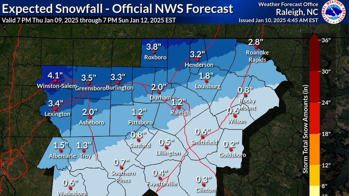
Light snow is expected to start falling between 3 p.m. and 7 p.m. Friday in central North Carolina, moving from southwest to northeast. Wintry precipitation should begin falling in Raleigh and the rest of the Triangle after 5 p.m. Friday. Freezing rain is expected, possibly mixed with snow and sleet, but becoming all freezing rain after 1 a.m. The low will be around 28 degrees.
The latest forecast shows the area could get total snow and sleet accumulations of up to 4 inches with ice accumulations up to a quarter-inch, depending on the storm track and how it interacts with the cold air already in place over the state.
Wake County schools will dismiss students three hours early Friday. Most Wake high schools will dismiss at 11:18 a.m. Most middle schools will dismiss at noon. Most elementary schools will dismiss at 12:45 p.m.
Orange County Schools will dismiss three hours early. Dismissal times will be 11:30 a.m. for elementary students, 12:25 p.m. for middle school students and 1 p.m. for high school students.
Johnston County Schools will dismiss three hours early. The Early College Academy and the Career & Technical Leadership Academy are closed to students and staff all day.
Chapel Hill-Carrboro City Schools will dismiss students two hours early. Dismissal times will be 12:35 p.m. for elementary schools, 1:20 p.m. for middle schools and 2 p.m. for high schools.
Chatham County Schools will release all students at 11:30 a.m. Friday.
Korie Dean covers higher education in the Triangle and across North Carolina for The News & Observer, where she is also part of the state government and politics team. She is a graduate of the Hussman School of Journalism and Media at UNC-Chapel Hill and a lifelong North Carolinian.
From the forecast and power outages to closings, road conditions and sporting events, here’s everything you need to know about the winter storm in the Triangle.